
WWI Cave VR Project
Creative Director, 3D Scanning Specialist
Vauquois, France, Summer 2017 – present
Funded by an Institute for Creativity, Arts, and Technology (ICAT) SEAD (Science, Engineering, Art, and Design) Grant
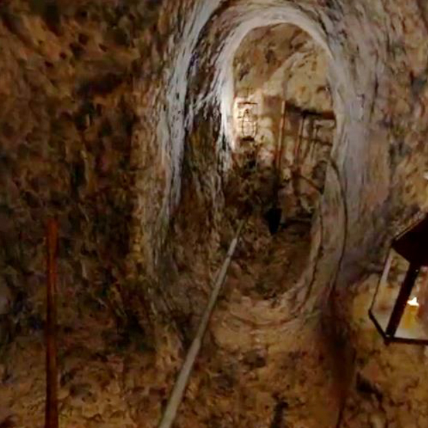
Vauquois was a small village before it became critical high ground that was fiercely contested for four years by the French and Germans during World War I, with the Americans finally taking the position during the Meuse-Argonne offensive of 1918. In an area smaller than the Virginia Tech Drillfield, a quiet, agricultural village became a killing ground starting in the streets, moving to trenches, and finally moving underground into a network of miles of tunnels used to set over 500 mine explosions in four horrific years of endless combat.
Our team of technologists, artists, educators, historians, engineers, and archaeologists performed a comprehensive site survey of the Hill of Vauquois, combining ground penetrating radar, photogrammetry, and laser scanning to create a digital recreation of the above and below ground features of the craters, trenches, tunnels and galleries that allows us to see Vauquois as it has never been seen before. The story is told in an immersive experience using 360-degree video, animation, and virtual reality. For example, audience members wear virtual reality goggles and walk through a 3D space that mimics the trenches. They will hear, touch and see what these miles of tunnels felt like for the soldiers.
As creative director and 3D scanning specialist I worked with all the technologies mentioned above to create an overall educational immersive experience. I led students to model the forms and to translate all the cave data.
Collaborators: Zach Duer, visual arts faculty member, Dongsoo Choi, visual arts faculty member, Todd Ogle, senior associate director of applied research and planning and ICAT Fellow; David Hicks, history and social science faculty member, Doug Bowman, Dongsoo Choi, visual arts faculty member; and Run Yu, Huy Ngo, and Xindi Liu